
|
|
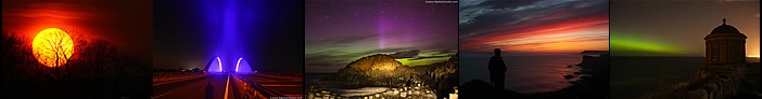
I'm only getting around to doing this report now a full three months since these images were taken and as I write these words we are in the middle of Autumn and pondering whether or not we will get a severe Winter this year so it gives me great pleasure and warmth to reflect back to this hot and humid period during July which presented me with my busiest period of storm chasing so far. You can read more about this period and the other chases I did during this crazy time in the other reports via the 2013 section. I was never going to do this report as I'm not a fan of storm images captured from built up areas as I'm the kind of person who likes to shoot storms over fields, lakes and open roads however on occasion storm shots from inside a city can look dramatic and often provide a sense of earth and sky connection so this is why I decided to go ahead with this report not to mention the great memories this time invokes in me, and also because this period presented me with the finest close range updraught base I have ever seen.
To cut a long story short, we had an amazing two week heat wave followed by a major thundery breakdown which also lasted two weeks so I took full advantage of the opportunity and chased every single day and even successive days in Co. Fermanagh which you can read about in the other reports. This time it was the weekend and I planned on spending the time with my girlfriend Roisin in Belfast so before I got on the bus I checked the charts and was delighted to see that Saturday and Sunday offered widespread storm chances and the models indicated that the best of these would be in the midlands and east of the country so I made a vow to be on full alert and I made a point of bringing all my camera gear including extra lenses and tripod, it was extra wait to carry however it was worth the effort, there is a saying I have never forgotten which I either saw in a film or read in a book which goes along the lines of ''better to have it and not need it than need it and not have it'', I have always been a believer in this mind-set when it comes to photography because rest assured something cool will happen once you leave your gear behind or let your guard down, so by at least bringing what you need you have taken out personal insurance and at the same time letting the universe know that you are fully prepared and ready for anything, I have digressed quite a bit here but you get the idea.
 |
Saturday and Sunday were looking good with high CAPE, a slack SWly flow, cold air aloft, very strong solar heating, plenty of moisture, convergence, and enough wind shear for organisation. The end result was a moderate risk of showers and thunderstorms with flooding being a real possibility. So this was the 28th on a glorious sunny warm day in Belfast, Roisin and I decided to enjoy the weather and walk to Forestside shopping centre and do some shopping however my shopping mentality was gone and I found myself glued to the sky so periodically I would leave the shop and take images from the car park. It was hard to leave the sky alone for 5 min's as convection was firing like crazy over the north side of the city, this was one of several big cells which just erupted into the clear blue sky and soon the charts showed it to be dropping a few c-g bolts over that area, I wish I had been closer but it was still cool to watch the storm grow from this distance.
 |
It stayed quiet over south Belfast all afternoon so I spent the time checking the radar on and off while reading and enjoying the sun in the back garden. By late afternoon around 17.00 onwards I had become engrossed in a book inside the intense heat of the conservatory and suddenly felt a strong compulsion to check the sky, it was my instincts again informing me that something was cooking and since they never let me down I acted immediately and walked into the sunny garden for a look. Nothing to the S or W however once I turned to the NW I said out loud ''holy ****'' for there was a stunning line of convection behind the house, the roof was blocking it so I went out the front door onto the street and had the same problem, I could see the tops but no base at all so I ran back inside and upstairs and found a great view through a large window. As I watched, within 15min's, the convection exploded into a massive multicell thunderstorm, here's an image shot through the glass.
 |
It looked amazing visually and was a beast and I had quite frankly worked myself into a state due to the excitement, the storm was slowly moving into the north and was passing L to R and into the distance from my vantage point, I suddenly wanted to chase after it and since I had no car with me I felt panic as if I was chained to the ground. I came up with stupid ideas like walking into the city but the storm was miles away and I would lose the view behind tall buildings and it would be gone by the time I got there, what about a bus or taxi? - ridiculous, what was I going to say? - ''follow that storm'', that would be a laugh. The storm was a beauty with brilliant white sunlit anvil with new updraughts going up towards the flank and sides of the primary storm, there was no question from looking at it that this was the storm of the day and I felt helpless standing here watching so I took as many images as I could and checked the radar which confirmed everything I already knew.
An idea came to me like a bolt of lightning if you will excuse the pun. Roisin's Sister Linda had arrived so I came up with the plan of asking Linda if she would take Roisin and I out on a local storm chase, she was a little surprised by the idea however she agreed that she would once dinner was over which made me very happy. Roisin's dinners are absolutely gorgeous however this was the first time I wanted it to be ready and over and done with as time was ticking and the storm was growing and moving away. The dinner was delicious and I'm pretty sure I had mine consumed in two min's and with a little encouragement Roisin and Linda had finished too and we hit the road. The plan was simple, head N and get outside the city onto high ground for a better view of the base in case there was a funnel or tornado.
We drove through the city and it's numerous traffic lights then climbed onto very high ground then stopped for a look, I heard a few distant rumbles so we went on in that direction for a few more miles, I don't know where exactly we stopped but it was near a junction on a country road on a very elevated location. We could see for miles to the W and NW towards Antrim and the Sperrins. There was a lot of cloud covering the structure however I could see the massive base and rear of the storm miles away and too far to catch so I took images then set up my tripod and began shooting video. I saw several in-cloud bolts flash and even got one on the video which was a nice treat however we had missed the best of it, had we left earlier we would have been rite beside it so we decided to let it go. This storm turned into a significant cluster which affected a large portion of the country extending from north Belfast, Antrim, and even towards my home in Mid-Ulster, there was significant lightning from the storm and severe flooding in Draperstown and Magherafelt, the latter had water running through the town like a river.
As I was standing by the road taking video a car pulled up beside me and a girl inside asked me about the storm, she had been walking her Dog earlier and had been watching it too, she also said she knew who I was, I think I was called 'the storm man' or something and she let me know that she followed me on twitter. That was quite surreal standing in the middle of nowhere where I have never been before watching a storm and a random person stops and says they follow me on twitter, it's just such a weird thing, anyway she drove on after the storm then Roisin, Linda and I began the drive back home, we didn't get close and personal with the storm but we did our best and it was a fun chase outside Belfast to the add to the list, I paid Linda fuel money for her time then Roisin and I chilled out back in the house, and after all, there would be more storms the following day.
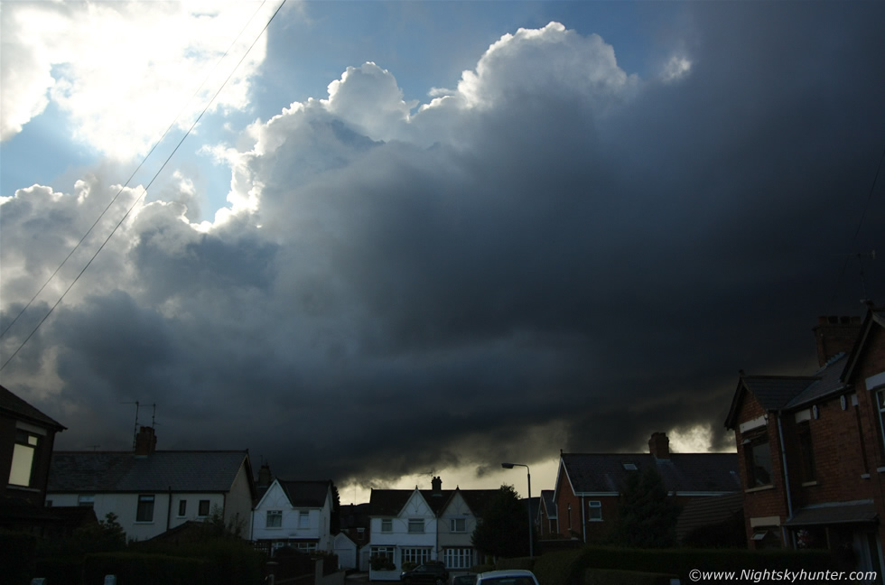 |
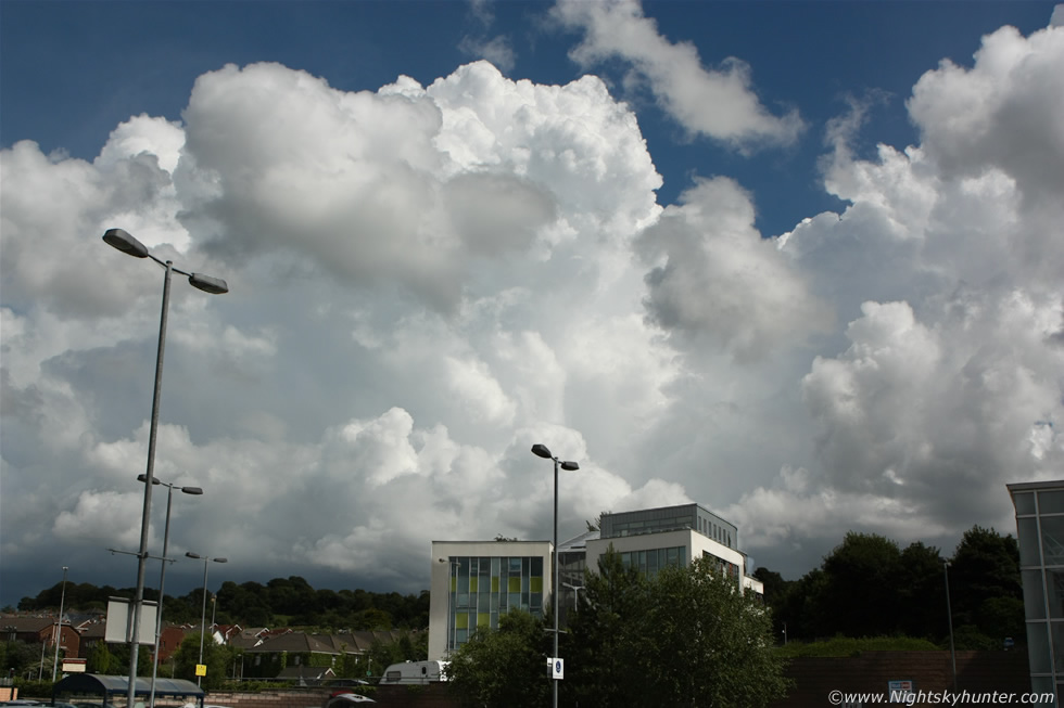
July 29th was another active day and much to my delight a thunderstorm passed over south Belfast during the early afternoon with a nice black shelf cloud and i-c lightning accompanied by loud thunder and once it passed the weather became quiet and the radar showed activity taking a back seat so I assumed that was it for the day then the hot sunshine was back out. Fast forward to late evening, I was training indoors when on several occasions I thought I heard thunder however I blew it off as noise from the numerous low flying aircraft here however I heard another rumble and this time I knew it wasn't a plane so I walked into the back garden once again for another look at the sky. Directly in front of me, due west and over the mountains, was a beautiful thunderstorm with a line of tall solid updraughts all back-lit by the sun and they where slowly getting closer. I grabbed all my camera gear and tripod and set-up everything on the foot path out front. I recalled that I had brought my tripod (I knew there was a reason to bring it) so I attached my video camera and positioned it at a strategic angle and let it record the storm creeping towards me. Here's the scene standing in the middle of the road looking directly west as it advanced. Those are the updraughts (towers) of the storm and the precip was falling away to the NW (R) of the city.
 |
The storm wasn't memorable for it's lightning activity although I did hear periodic rumbling thunder which sounded like it was occurring in slow motion, however the storm made up for it by it's structure. This was between 19.00 and 19.30 in the evening when the sun was low in the sky and the light was warm and contrasty. The main bulk of the storm clouds were back-lit and hence dark with a purple/blue hue however below the storm the updraught base and precip were lit up into a most beautiful warm tan colour, the sight was difficult to show on camera but a real treat with the naked eye. Here's the scene at 10mm, the storm was moving straight towards me and the area out of frame to the R was where precip was falling with lightning. I took many images here with different lenses from the bottom of the road and above, pretty much searching for the best angle possible.
 |
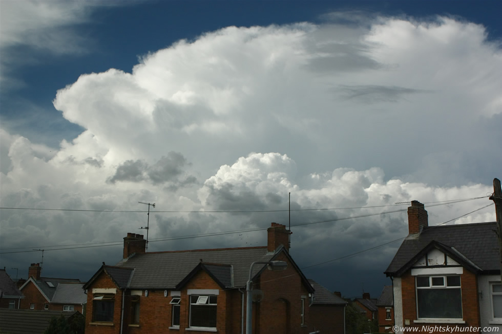
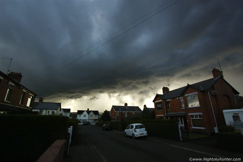
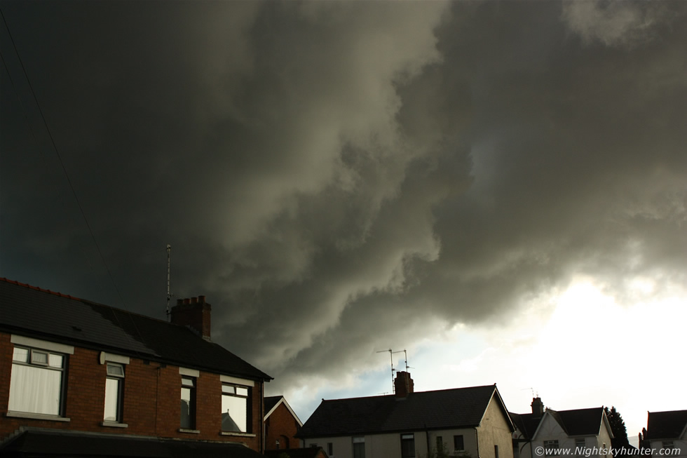
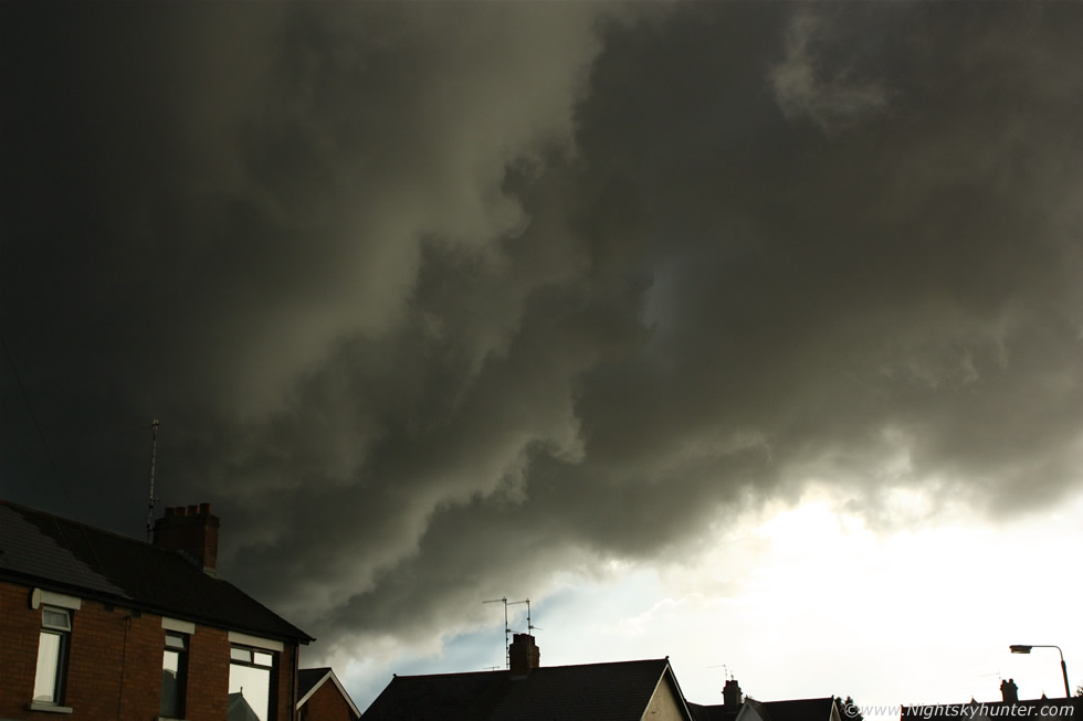
This scene was the highlight of the day and the photogenic trophy from the weekend. This is what's called the 'updraught base' of the storm or 'rain free base' or simply the base. There is a reason why storms are also called cells and that's because they can be compared to living cells in the sense that they breath in and out just like a living organism. Breathing in is 'inflow' and breathing out is 'outflow', the outflow is all the rain, hail, lightning, cold air and wind in association with a gust front - often sporting a shelf cloud feature - which is the visible manifestation of a storm which has tipped it's balanced life style towards the breathing out mode.
The inflow (breathing in) feature is always underneath and to the rear of any organised storm, the storm actually sucks in warm moist air through the base which then gets transported vertically high into the atmosphere (at rapid speed) into the updraught (tower). If this updraught happens in an environment with the correct amount of speed shear (change of wind speed and strength with height) and turning (change of wind direction with height) then these updraughts can produce funnel clouds and tornadoes. This is why many eye witnesses who observe or experience a tornado in Ireland/UK often describe the wind and rain passing then it turning calm with the sun coming out and that is when the vortex is seen. The above image is a perfect example of this storm feature, this is the finest and most highly structured thunderstorm updraught base I have ever seen.
 |
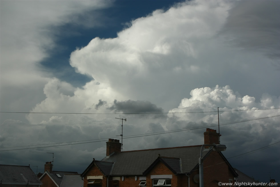
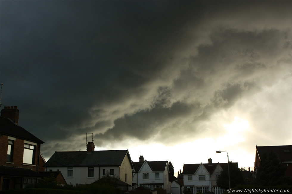
My video camera was rolling the entire time too so I have the passage of this structure recorded going rite over the houses here. This is where the storm feeds and also where funnel clouds and tornadoes can drop so I was watching the base with deep concentration and felt the excitement building not knowing what was going to happen next. I wonder if the people indoors knew what was passing over their homes, getting closer here and moving R to L.
 |
I observed very keen churning and lifting motion under there. Standing here watching this storm feeling hot and humid in a t-shirt on a Summer's evening is like heaven to me and it makes me smile thinking back on it now.
 |
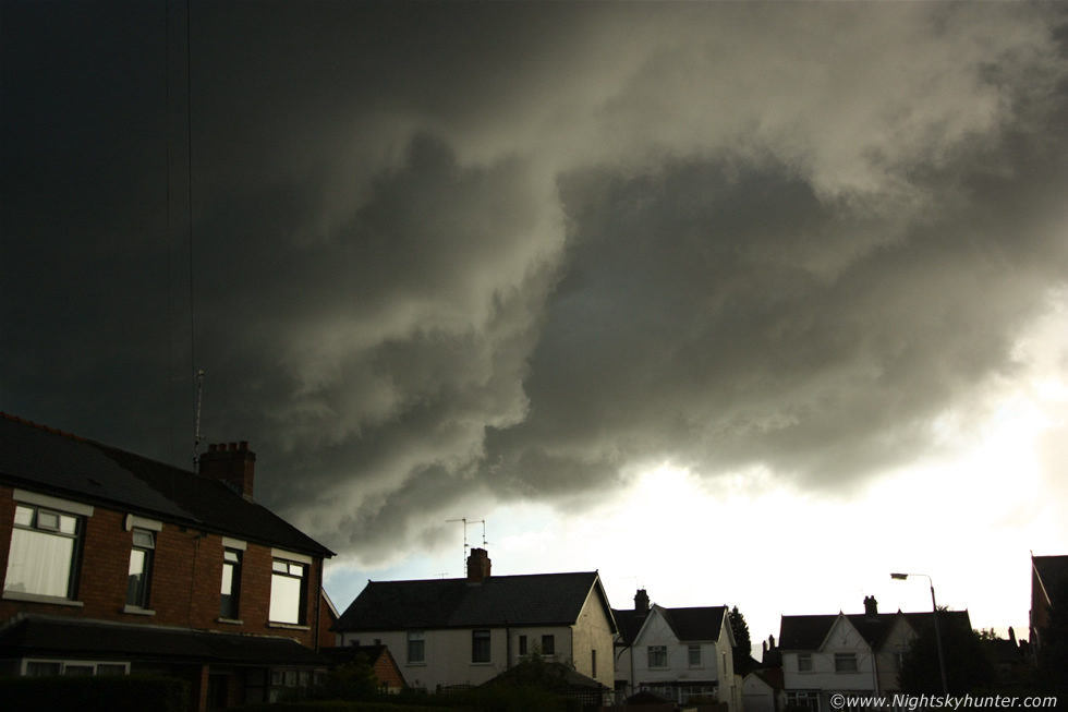
Rite overhead looking menacing and dominating the sky so I ran through the house into the back garden and shot video of it passing directly over the house. As the updraught base passed across the zenith it seemed so low in the sky that it almost looked as if it was going to snag on the aerial. The clouds were solid, black, charcoal grey with blue sky to the side and the sun broke out adding bright rays and crazy light to the scene, each drop of rain falling from the sky was glittering like a diamond as it reflected the bright sunlight which you can watch on the latter half of the second video, it really was a great experience. The storm moved into the east and weakened so I had caught it at it's very best, no funnels or tornadoes however one can't beat close range storm structure like that.
First video clip over 5 min's in duration which documents the storm moving in at wide angle with several rumbles of thunder then with attention focused on two areas of the large updraught base. Motion is real time so you can almost sense what it was like to be there. I accidentally had my video camera on auto white balance which is why there is a strong blue cast in the video, this was a mistake as I forgot to switch it to cloudy, in reality the clouds were very 'warm' underneath.
My favourite clip over 6 min's in duration of the entire dramatic updraught base moving in real time. Look carefully between 47 and 57 sec's in and you can see a very well defined crescent moon-shaped cloud detach itself from the base which is really cool, I have never seen this before from a storm base, the entire base itself is turning slightly too. There is more thunder then the clip continues in the back garden looking overhead at the base as sunlit precip falls from the sky creating wonderful visuals with flares and sun beams playing against the dark storm clouds, you can see nice rolling motion which really picks up speed. I love this video clip, the clouds are very dramatic and definitely a clip for the storm structure fanatic. Good job I brought the tripod with me or I would never have been able to get good video and still images at the same time - better to have it and not need it than need it and not have it - I needed it and it paid off to get this footage. Thanks very much for reading.
Martin McKenna